
Looking Beyond the Map Point
Traditional dengue risk models often assess the environmental conditions at the precise location where a case has been reported. But mosquitoes, people and climatic conditions do not stop at a single coordinate.
In a new medRxiv preprint, Carlin Foka Takamgno and colleagues developed a deep-learning model that instead examines the landscape surrounding reported dengue locations at three different spatial scales â local, neighbourhood and broader landscape.
âMany models used to map dengue suitability examine the environmental conditions at a single point, for example, they use information such as the temperature or population density at the exact location where dengue was reported, while overlooking the surrounding area,â explains Foka Takamgno. âHowever, mosquitoes, people and climatic conditions are not confined to a single coordinate.â
The distinction matters because a location that appears relatively unsuitable when considered in isolation may be surrounded by conditions capable of supporting dengue transmission.
The researchers found that neighbourhood conditions provided the strongest signal, although information from all three spatial scales contributed to the model. Compared with conventional point-based approaches, the model identified 6â18% more environmentally suitable land across South Asia, Southeast Asia and South America â areas collectively home to tens of millions of people.
Feature analysis also identified population density as the strongest overall predictor of dengue suitability, followed by dengue temperature suitability, poverty and minimum temperature during the coldest month.
For Foka Takamgno, looking at multiple spatial scales provides a more complete picture of where dengue transmission could potentially occur. âTwo locations with similar temperatures or population densities may have different levels of suitability if their surrounding environments differ,â he says. âBy examining local, neighbourhood and broader landscape conditions, the model can detect spatial patterns that point-based models may miss.â
Better maps could ultimately help countries decide not only where to strengthen surveillance, but where to direct resources when an outbreak occurs.
Densely populated urban and peri-urban areas identified as highly suitable may warrant closer disease and mosquito surveillance, stronger vector control and better-prepared health services. During an outbreak, the maps could also help authorities look beyond locations where cases have already been detected.
âThe maps could help authorities direct staff, diagnostic tests and other resources towards suitable surrounding areas, rather than focusing only on places where cases have already been reported,â says Foka Takamgno.
At the same time, he cautions against focusing exclusively on individual hotspots or major cities. Because local, neighbourhood and broader landscape conditions all contributed to the model, targeted interventions need to be accompanied by coordinated national surveillance and response planning.
Read the full paper, and list of authors, here
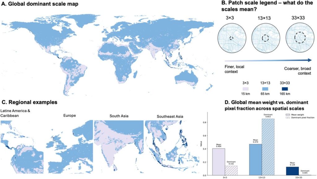
Figure 2 (above): Spatial-scale contributionsto the multiscale CNN-DRE.
(A) Dominant spatial scale globally. (B) The three neighbourhood scales: 3Ã3, 13Ã13 and 33Ã33, representing approximately 15, 65 and 165 km. (C) Regional patterns across Latin America and the Caribbean, Europe, South Asia and Southeast Asia. (D) Relative contribu-tion of each scale. Neighbourhood-scale context dominated 85.3% of land pixels, followed by local at 14.2% and broader context at 0.5%.
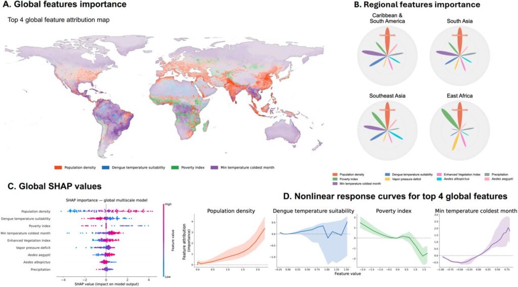
Figure 3 (above): Key predictors of dengue suitability.
(A) Global distribution of the four leading predictors: population density, dengue tempera-ture suitability, poverty and minimum temperature in the coldest month. (B) Regional differ-ences in predictor importance. (C) Global ranking of predictors. (D) Relationships between predictors and model attribution. Population density was the strongest global predictor, while other socioeconomic and environmental influences varied by region.
News date: 2026-09-03
Links:
KRISP has been created by the coordinated effort of the University of KwaZulu-Natal (UKZN), the Technology Innovation Agency (TIA) and the South African Medical Research Countil (SAMRC).


Location: K-RITH Tower Building
Nelson R Mandela School of Medicine, UKZN
719 Umbilo Road, Durban, South Africa.
Director: Prof. Tulio de Oliveira